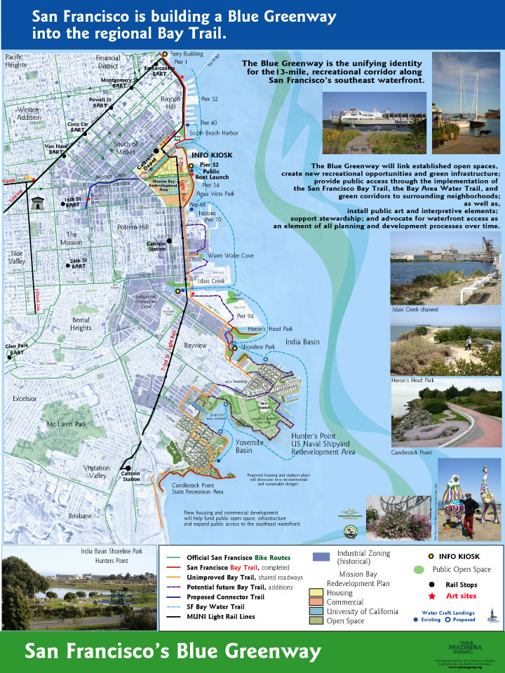
The Blue Greenway is being planned now! The BGW concept is to connect neighborhoods from China Basin to Candlestick Park to each other and to the water. Some great project have already begun on Port property (for example, Heron’s Head park entrance). Come see the rest of the current plans -- and share your ideas for how the Blue Greenway can best serve India Basin, Hunters Point, and the Bayview.
SAVE THE DATE
The next presentation on the draft Blue Greenway Planning and Design Guidelines will be at the Port’s Southern Waterfront Advisory Committee (SWAC) on Wednesday, August 17, 2011 between 6:00 - 8:00 PM at the Eco Center at Heron’s Head Park located at the end of Cargo Way. Click here for a map
FYI: I have read the planning document and think the planning for India Basin past the Port property is weak and that the whole thing is not well linked to what we’ve heard is planned for the Shipyard. There are also 30-foot tall signposts planned for the entire length of the Blue Greenway that residents might want to check out since we will be living with them for years to come.
If you are interested in how the Blue Greenway can benefit our neighborhoods, and serve as the comprehensive planning method it claims to be, you might want to check out these documents and/or attend this meeting. Blue Greenway planning is paid for through a voter-approved bond -- it is our tax money at work! Let’s make sure it works for us.
IBNA will be submitting comments to this plan, but individuals are also welcome to comment to the Port about the plans.
Draft Planning and Design Guidelines

Showing posts with label Blue GreenWay. Show all posts
Showing posts with label Blue GreenWay. Show all posts
Monday, August 1, 2011
Blue Greenway presentation Aug 17
Today, from Jill Fox of the India Basin Neighborhood Association:


Wednesday, June 22, 2011
Blue Greenway Bike Tour
 Saturday, June 25, 10:00 am - 2:00 pm
Warm Water Cove to Candlestick Point
RSVP & More Information
Join the Neighborhood Parks Council and the Bicycle Coalition this Saturday, June 25, as we pedal the Blue Greenway; a land & water network on San Francisco’s south eastern waterfront from China Basin to the Southern Border. This tour will stop at 6 locations along the waterfront to identify future bicycle connections, gaps in the existing trail system, and opportunities for bicycle access along the southern waterfront. FREE
· The tour begins at Warm Water Cove (24th Street/Michigan Street)
· India Basin / Bayview folks: There will be a stop at India Basin Shoreline Park to hear about the Community Vision for new active recreation and transit opportunities on San Francisco Bay.
· Riders will pass through the Hunters Point Shipyard—open just for this tour!
· The tour ends at Candlestick Park State Recreation Area.
Enjoy breathtaking views of the bay, learn the history of the area, and enjoy a thrilling ride on the Blue Greenway!
Monday, December 20, 2010
Job Announcement: Blue Greenway Brownfields Area-Wide Plan Project Director
Attached is the job description for a part-time Blue Greenway Brownfields Area-Wide Plan Project Director, the position that will facilitate Neighborhood Parks Council’s EPA grant (for planning cleanup and reuse of San Francisco’s southeast waterfront). (h/t Jill Fox)


This is a new position for NPC and Corinne Woods continues in her role as the Blue Greenway Coordinator.
Contact Meredith Thomas, Executive Director, Neighborhood Parks Council, 451 Hayes Street, Second Floor, San Francisco, CA 94102
p:(415) 621-3260; f:(415) 703-0889
www.sfnpc.org ; www.ParkScan.org
Subscribe to:
Posts (Atom)